


Australia Topo Maps
Australia Topo Maps介绍
易于使用的户外/离线GPS导航应用程序,可访问澳大利亚最好的地形图和卫星图像。
++对于离线使用,需要PRO功能! ++
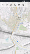
将您的Andoid手机/平板电脑转换成室外GPS,即可无障碍地进入偏远地区。该应用程序为您提供了类似Garmin或Magellan GPS手持设备可能知道的相似的映射选项。
包括免费地图图层:
•NATMAP 1:250.000 Topo Maps,最新版本,增加了阴影和其他地名!
•Getlost地图:完整的澳大利亚的地形图和旅游地图,比例为1:75.000和1:250.000,Victoria&East NSW为1:25.000
•澳大利亚基础地图:整个澳大利亚的无缝国家数据集。很详细!
•昆士兰Topo地图:HiRes地形图
•新南威尔士州地图:HiRes地形图(扫描的栅格和数字地图)+ HiRes影像
•南澳大利亚州:HiRes地形图和街道图
•塔斯马尼亚地图:HiRes地形图+ HiRes影像
•北领地地图集
•OpenStreetMaps:这些众包地图是对其他地图图层的非常有用的补充。包含许多独特功能。
•OpenCycleMaps:这些地图非常适合计划自行车旅行
•地质图(适用于生物学家,地质学家,矿工等)
•ESRI地形图
•ESRI航空影像
•ESRI街道地图
•Google路线图(仅在线访问)
•Google卫星图像(仅在线访问)
•Google地形图(仅在线访问)
•必应路线图(仅在线访问)
•Bing卫星图像(仅在线访问)
•夜晚的地球
•山体阴影和轮廓线(20m)覆盖(全球)
•运输/基础设施覆盖
高级地图图层:
•维多利亚1:25.000
仅需78,99 $(AUD),您就可以无限制地访问所有25k Vic地形图(865张地图!)-缝合在一起形成无缝的mosaik(完整覆盖)!易于下载和离线使用!在Vic DELWP办公室,单张GeoPDF地图的价格为8.5美元!
•西澳大利亚州1:25.000-1:100.000
仅需154,99 $(AUD),您就可以无限制地访问所有可用的25k,50k和100k WA地形图表(3044张地图!)-缝在一起形成无缝的mosaik!易于下载和离线使用!在华盛顿州兰德盖特办公室,单张GeoPDF地图价格为12,6美元!
户外导航的主要功能:
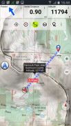
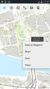
•创建和编辑航点
•导航至航点导航
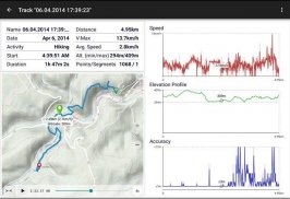
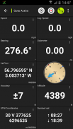
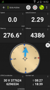
•跟踪记录(具有速度,高度和精度配置文件)
•Tripmaster,其中包含里程表,平均速度,方位角,海拔等字段。
•GPX / KML / KMZ导出
•搜索(地名,兴趣点,街道)
•地图视图和Tripmaster中的可自定义数据字段(例如,速度,距离,指南针等)
•分享航点,航迹或路线(通过电子邮件,Whatsapp,Dropbox,Facebook等)。
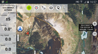
•以纬度/经度,UTM或MGRS / USNG(军事网格/美国国家网格)显示坐标
•记录和共享具有统计信息和海拔剖面的轨道
•旋转地图(向上和向北追踪)
•通过长按地图获取高程
•曲目重播
• 还有很多 ...
可用的专业功能:(可通过应用内购买获得专业功能)
•脱机使用-无需覆盖小区。没有漫游费!
•轻松+快速批量下载地图图块以供离线使用(不适用于Google和Bing地图)
•创建和编辑路线
•路线导航(点对点导航)
•GPX / KML / KMZ导入
•无限的航点和航迹
•添加其他地图图块服务器
• 无广告
离线使用:
所有查看的地图图块均保留在缓存中。要缓存大区域,您需要购买Pro功能。
使用此导航应用程序进行户外活动,如远足,骑自行车,露营,爬山,骑马,滑雪,划独木舟,狩猎,越野四驱车游览或搜寻与救援(SAR)。
添加带有WGS84基准的经度/纬度,UTM或MGRS / USNG格式的自定义航点。
以GPX或Google Earth KML / KMZ格式导入/导出/共享GPS航点/航迹/路线。
为没有小区服务的区域预加载免费地图数据(Pro功能!)。
对info@atlogis.com的评论和功能请求
+++我们不会跟踪任何用户活动或收集任何用户数据! +++
Australia Topo Maps - APK信息
APK版本: 7.7.2程序包: com.atlogis.australiaAustralia Topo Maps的最新版本
其他版本


同类应用


